
An EV Road Trip in Search of Fall Colors in Northern California
Few road trips start as grand as this one, but our road trip, in search of fall colors, was going to be different.
Starting at Lake Tahoe’s iconic Emerald Bay on a crisp morning, the Rivian R1S had the seats down and was loaded to the brim with camera gear, dog toys, suitcases, snacks, and hiking gear. Kristin, Chestnut (our dog), and myself were in for an adventure of a lifetime. Seeking fall colors throughout Northern California, we had planned a four-day road trip looping from Lake Tahoe to Yosemite National Park back to our home in Lake Tahoe via as many backroads as possible.
Emerald Bay just before the sunrise on the first morning of our road trip. Photo by Dalton Johnson


The sun poking over the Carson Range and blanketing Lake Tahoe in the much needed warmth marked the beginning of our projected 400 mile road trip. However, we knew our desire to take the roads less traveled to find the color popping foliage meant we would most likely be driving 1200 to 1500 miles. Kinda tricky considering we were in an EV for the first time and worried about how to charge and where to charge. On our list of dream destinations for fall foliage in Northern California we had the following list:
Kirkwood / Hope Valley
Angora Lakes Overlook

Our route in search of fall colors and epic hikes in Northern California. Google Maps
Pros
Using the Rivian, instead of my van, we saved $482 in fuel costs
Utilizing the downloaded maps version of AllTrails allowed me to stay on path while hiking and trail running in Yosemite National park
Pet Mode saved us with Chestnut when we needed to run into a store and leave him in the Rivian
Fall colors on Monitor Pass at sunset blew our minds, we timed that perfectly
Cons
Fall colors were later than expected, so not as grand as previous years
I should have used the AllTrails scenic roads to find more locations for the road trip, but I didn’t know about this feature until the last day
Having Chestnut, our dog, with us prevented us from exploring Yosemite National Park as much as we wanted

Driving through the aspen groves towards the Angora Fire Lookout. Photo by Dalton Johnson
The Night Before Leaving
Like I said before, neither Kristin or myself had ever driven an Electric Vehicle before, so the family hopped in the Rivian and took off with high hopes of finding some fall colors in South Lake Tahoe. We figured our best bet would be around the Angora Lakes area as the winding dirt road has several aspen groves dotting the landscape.
To our surprise, there were only a few groves that had started turning from green to yellow and orange. This year the colors were late.
Weaving up the slopes towards the fire look out, the grove’s started to show signs of color. A pop of yellow here and another pop of color there. Turns out, we just needed to gain some elevation. I’m no scientist, so I have no idea what it takes for the colors to change on aspen trees, but I enjoy watching the yellow leaves dance in the wind. As we drove, Kristin and I were eager about the colors that started to show, especially in the sunset light.
Swapping back and forth, Kristin and I became accustomed to the regenerative braking of an EV. Learning how to drive smooth was a challenge at first and our driving resembled that of 15 year old in driver training as we bobble-headed around the turns of the road. However, after twenty or so minutes of driving, we both were able to understand how to drive with a the single pedal.
Arriving at the lookout just in time, we watched the golden glow of sunset envelop all of the Tahoe Basin.

Kristin and Chestnut soaking in the sunset views from the Angora Fire Lookout overlooking Fallen Leaf Lake and Lake Tahoe from the Rivian Tailgate. Photo by Dalton Johnson

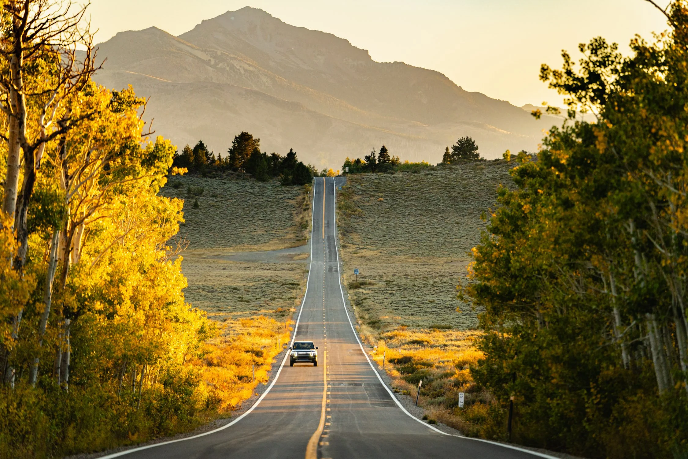
Exploring the dirt roads on the way to Yosemite National Park. Photo by Dalton Johnson
Lake Tahoe to Yosemite National Park:
Leaving Emerald Bay and with myself at the wheel, our journey was underway. Typically, we would drive south to Sacramento, down the Interstate 5, and then head directly to Yosemite Valley, but have you ever set eyes on fall colors along I-5? We haven’t! Instead, we routed a path through the two lane roads of Sierra Nevada Mountains. Often, taking dirt side roads to hidden lakes and mountain towns tucked at the base of cliffs calling out to be climbed. However, we would need to return at a later date for that, for this trip was about fall colors.
The Rivian has roughly 400 miles on a single charge, so we knew we could take as many backroads as our heart’s desired.
Kicking up dust as we made our way south, Chestnut was doing a great job laying in the spacious back seats and would occasionally poke us with his nose, letting us know he needed to use the restroom. As a puppy of 12 weeks, his bladder was small and this was going to be his first big road trip. Luckily, the air conditioner in the back of the Rivian could blow directly on him, keeping him cool on the journey.
After one of the mandatory potty stops for Chestnut, I was feeling ambitious. Our “fuel tank” said we had plenty of energy, so I slammed the pedal to the floorboard to test out how fast we could go. 80, 90, 95, 100, 105, 110, 111…
“That’s enough!” Kristin shouted in a nervous voice next to me as her fingernails dug into my thigh.
“That is crazy! This thing can rip!” I shouted back, wide-eyed with adrenaline.

Recharging at the Rivian Outpost in Groveland, CA. Photo by Dalton Johnson
Stopping in at the flagship Rivian Outpost in Groveland, CA to top off the tank, before heading into Yosemite National Park for the evening, we stretched our legs, grabbed a cup of Jelly Beans (honestly, we did spill them), met a few other Rivian owners, and learned about the new collaboration between Rivian and AllTrails. In the wake of the major overhaul to the AllTrails app, Rivian and AllTrails have teamed up to enable the Rivian community to get outdoors. To do this, stop in at the Rivian Outpost and scan a QR code that will unlock one free month of AllTrails+.
What does AllTrails+ Unlock for you?
Offline Maps: Download maps in advance to ensure you know your location even without cell service, a much needed feature in National Parks. This is by far my favorite feature!
Distance Away: Search for trails based on how far they are from your current location. Whether you have just an hour or an entire day, find trails that match your available time
3D Maps: View an enhanced visualization of trails, including peaks and valleys, to better understand the terrain before heading out. This is my second favorite feature as it allows me to visualize photography spots and scout new routes along the way.
Enhanced Map Details: Access real-time information on air quality, satellite weather, pollen, light pollution, and user heatmaps to plan your trip effectively.
Printed maps: Print customized maps with options for scale, orientation, gridlines, and paper size. Have a backup plan without needing guidebooks.
Wrong-turn alerts: Load a map or trail route into Navigator to get alerts if you veer off course, helping you stay on track and enjoy your surroundings.
Ad-free experience: In other words, you save time while searching and get to spend more time outdoors.


Half Dome glowing in sunset light while parked in the Olmstead Point parking lot. Photo by Dalton Johnson
Yosemite National Park
Without much light left in the day, the gang hopped back in the Rivian and headed into Yosemite National Park, only 24 miles away from the Outpost.
My first thought was to seek out some fall colors in Yosemite Valley, but I figured we wouldn’t have time. So, I took a left at Cane Flat and bolted along Tioga Pass to Olmstead Point for the sunset. To my surprise, we arrived with plenty of time and Kristin pulled out her Kindle to read and look out the window at the transforming skyline. The colors changed from blue to yellow to orange. Yosemite’s most famous rock formation, Half Dome, glowed in the omnipresent golden light and I snapped images while gawking at the stunning view.
When the light was gone, we headed back to our hotel to rest up for the next full day of hiking around Yosemite National Park.
Crocker Point and Breaking my one mile trail personal Best
After a casual morning at the hotel, I took off for Yosemite Valley to meet up with a long time friend while Kristin stayed behind to work and take care of Chestnut. My buddy, Scott, was looking for “a good hike that could be used as a recovery day between climbing days.” Turns out, he had taken the month off to climb in the High Sierra and was conveniently in Yosemite Valley at the same time. So, we met up near Camp 4 where he had been crashing and opened AllTrails to find a hike. The night before, I had downloaded several hikes I thought we might be interested in doing.
“What do you think of this one?” I would say and hand my phone to Scott.
“Nah.”
“This one? It’s got a stunning view.”
“Sure, but I just want to hike it. I don’t think I can trail run that far.” Scott made sure I wasn’t going to sandbag him into running like I typically try to do.
“Sweet! Crocker Point is one of my favorite hikes!”
Off we went. Heading to the rim along Glacier Point Road, my GPS cut out on my phone and we were left to navigate to the trailhead using the AllTrails app. Turns out, the offline mode is a great feature in National Parks.

Utilizing the downloaded map to navigate the trail to Crocker Point. Photo by Dalton Johnson
With our packs over our shoulders, we picked up the trail and started our 10.1 mile hike along the Ponoho Trail to Crocker Point. Wandering through heavy vegetation we lost the trail occasionally, but, the “Wrong Turn” notifications corrected our misguided direction. After a few miles, we started diving into stories about climbing, picking up our friendship right where it was left off when I moved away from Santa Cruz a few years back. Scott and I typically climb together at least once a year, some-where, and this year it was in the Palisade Range of the High Sierra. That was only a few weeks ago, so I was curious to hear how his recent climbing experiences were tallying up.
Overall, he was crushing. Getting in several good leads and it was evident he was feeling strong on this trip.
Time moves quickly when you are hiking with a friend, sharing mutual goals, and planning for the future. So, when we reached the first point, Dewey Point, in what felt like no time, we were a little blown away. Four and half miles went quick. Laughing and joking about being “the best hikers in the world” we continued over to Crocker Point. A place I had only been in the winter, but preached to Scott as being “the best view of the Valley.”
Again, that half mile flew by and we took in the views.
“So, what do you think?” I questioned Scott looking for him to confirm my bias that this was the best view from the valley rim.
“Its stunning. Thanks for bringing me here. Not sure it’s the best, but really nice.” He said with a smirk, knowing I wanted him to confirm Crocker Point was the best view point of Yosemite Valley.
On our way back, Scott asked, “Do you have any goals right now?”


“Not really, but I have been somewhat trying to break my personal best one mile time on a trail.”
“How fast?”
“I need to go faster than 6:24”
“Do you want to try right now?”
“Right now?”
“Yeah, why not? Plus, the next mile is totally down hill, so that should be helpful” Scott claimed.
I laughed and responded, “Sure, let me get some music cued up for us to rip down this hill. You running too?”
“I’m not going to let you run alone.”
“Coming from the guy who said no trail running this morning, I’m a bit surprised.”
“People change their minds.”
So, I cued up some rap music, tied my shoelaces, and cinched down my backpack that was loaded with a camera, journal, a water bottle, some snacks, and a few miscellaneous items. Honestly, I thought this was silly as I didn’t think I could break a personal best with a pack weighing roughly 12 lbs.
“Let’s start with a really short jog to the start of the downhill, then take off like a bat out of hell, to break this thing. Sound good?”
“Let’s go!”
Off we went. Jogging at first and then sprinting down hill. Immediately, we had a to hop over a log and take several quick turns. I thought I might roll my ankle, but I didn’t want to leave any excuses on the table. At a full sprint I did everything I could to break my personal best. Rocks popped out of nowhere and foliage covered the trail. But, I kept sprinting. Scott was no longer in sight when I looked over my shoulder. My lungs were burning and I had that taste of iron in my mouth. Most likely the elevation. Still I sprinted.
“How fast did you go?” Scott asked.
“6:22!”
“Hell yeah!”
We high-fived in celebration and kept hiking out to the car.
Monitor Pass at sunset with a pop of fall colors. Photo by Dalton Johnson
Sunset At Monitor Pass on our journey home
Waking up with a cough after the run, Kristin laughed at my stupidity, “You and Scott always get up to something, don’t you?”
“I can’t deny that.”
This morning was the penultimate for us, so we enjoyed the hotel, packed up the Rivian, and began our journey home. First, we wanted to go for a little trail run in Tuolumne Meadows. So, while we drove through Yosemite National Park keeping an eye out for any fall colors, without much luck, we planned our trail run for the day. Kristin wanted to get in a few miles to break up the drive home and I needed a recovery run from the day prior.
Settling on the Glen Aulin trail, we parked the vehicle, turned on Pet Mode, and hit the trail. Both of us wished we could have had Chestnut run with us, but dogs just aren’t allowed on any trails that are not paved. We felt like bad paw-rents, but with Pet Mode, leaving Chestnut in the car for thirty minutes while we jogged a few miles didn’t seem like the worse thing we could do to him.

Chestnut sitting co-pilot when the Rivian is in Pet Mode.
Arriving back to the Rivian, Chestnut was fast asleep. Waking him up and feeding him lunch, we hit the road north, towards Lake Tahoe.
Driving along Highway 395, there are so many stunning places like Mammoth Lakes, Travertine Hot Springs, and Mono Lake, but we didn’t stop there. We had our eyes set for Monitor Pass at sunset. Which, according to our GPS left us little time for stops along the way, so we powered our way to the left hand turn off HWY 395 onto HWY 89.
Time was ticking and the sun was fading, fast. We drove up, up, up towards the summit. Our fingers were crossed we would make it to the pass just in time because I had heard a rumor from fellow photographers that the colors at the summit were bright yellow and orange. With Kristin at the wheel we sped our way north as I prepared my camera gear.
“Let me out here,” I said to Kristin as we arrived just in the nick of time.
Using walkie talkies, we chatted back and forth to coordinate a photograph that made me happy. ‘Okay, go, go, go.” I spoke into the walkie talkie fearing the light would fade and we would miss the shot.
Cherck, Cherck, Cherck
The camera snapped as Kristin and Chestnut zoomed past in the Rivian.
“I think we got it!” I shouted into the radio excited. “Come on back and pick me up. Let’s go home!”


